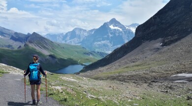
This article aims to introduce you to some of the most beautiful hikes around Lake Annecy. The itineraries have been carefully selected by the mountain guides of the Annecy guide bureau for their specificity, beauty and attractiveness.
At the Annecy guide office, we offer you the opportunity to discover them in safety and under the supervision of passionate mountain professionals. The outings will be an opportunity for you to learn about the fauna, flora, geology and the heritage so specific to our mountains.
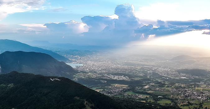
La Tournette: The citadel of Annecy Lake
D+ 950m
D- 950m
Duration: 6h
Type of route: Round trip
Difficulty: Very good walker
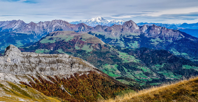
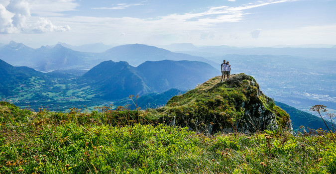
La tournette is in a way the Mont Blanc of Annecy, which can be seen from all around the lake and which dominates it from the top of its 2351m. The origin of the name is not clear but some studies in toponymy agree that it is a "high" place. Moreover, La Tournette was for many years the route for the Brevet d'Alpinisme Militaire (Military Mountaineering Certificate) for the 27th Battalion of Alpine Hunters. It is therefore a hike not to be taken lightly.
There are several possible routes to the summit. You can start from Thônes on its eastern slope by starting from the place called "Les Chappes" and passing by the Rosairy hut. Or from Serraval to the Praz Dzeures hut.
At the guide office in Annecy, we prefer the western ascent "lake side" which is however the most vertiginous. We usually start at the chalet de l'Aulp.
Beware the access path by car is gullied in some places.
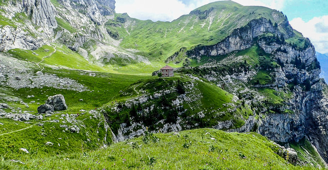
The ascent in the mountain pastures is immediately sustained, you have to catch your breath and manage your effort because the climb is still long. After leaving the alpine pastures, our progress will be made in a twist on a stony path below the Pierre Châtelard. We reach a big bend that leads us to the Tournette hut (closed) at the foot of the Casset escarpment.
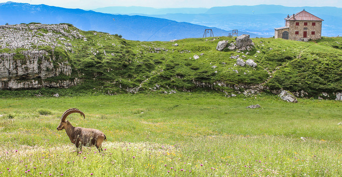
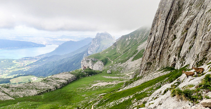
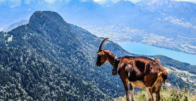
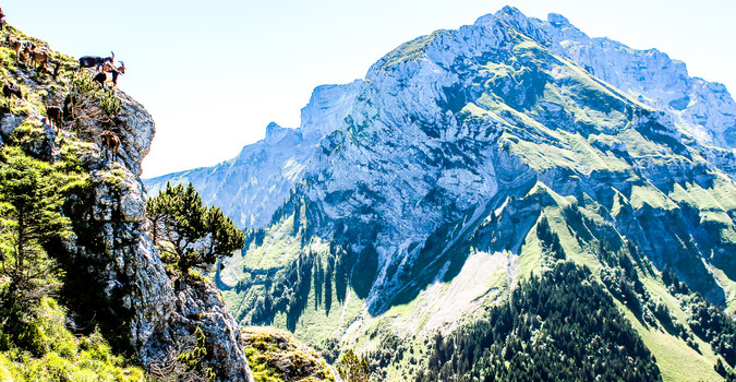
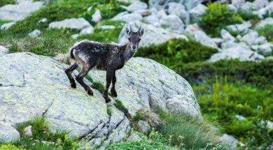
In general if we left early enough, you will be able to observe the ibexes in this area that let themselves be approached up to a few meters.
From the Chalet du Casset, there is an itinerary that goes under the Pierre Châtelard.
Be careful, this itinerary is reserved for expert hikers. It is not marked and some passages are easy to climb.
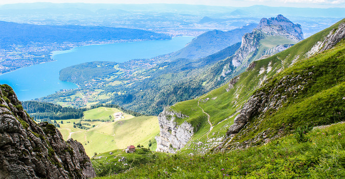
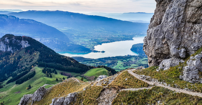
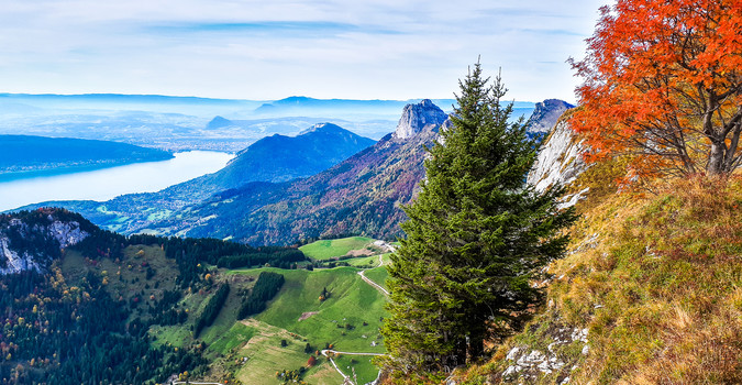
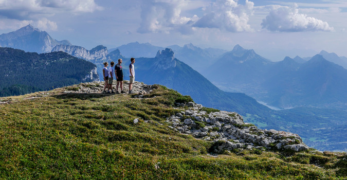
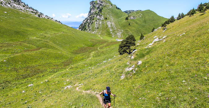
We continue our walk until we reach the coomb below the top of the Tournette. The progression is done on lapiaz and thus becomes a little more technical. You have to put your hands on some places to balance yourself. Afterwards, the evolution becomes easier. Arriving at the Col du Varo, the view opens out over Lake Annecy, the Bauges massif, the Thônes valley and Saint-Jean-de-Sixt revealing the Aravis mountains.
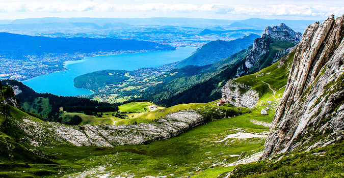
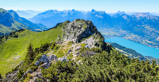
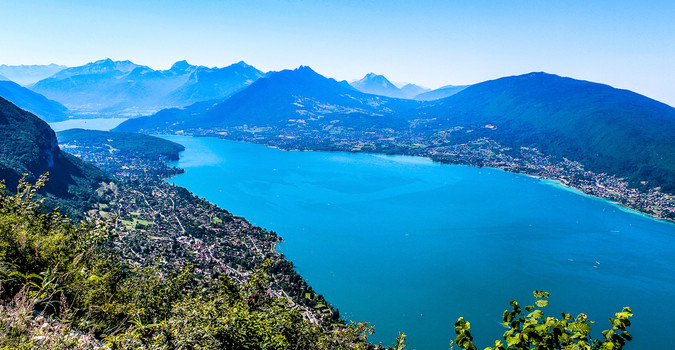
The last part of the ascent, after the Col du Varo, is the most technical. Some passages are equipped with chains and cables to facilitate the progression which is done on narrow bends in some places. You will have to put your hands on very short sections again to balance yourself. Once at the foot of the "armchair", the top part of the Tournette, a last effort will be necessary to reach the highest point. The passage will be guided by chains and a ladder. Once at the top, the reward is a 360° panorama. Below, we overlook Lake Annecy with its turquoise colours, to the east we contemplate the Aravis mountain range with its highest peak the Pointe-Percee which culminates at 2752m. Then in the background, the Mont-Blanc massif, the highest summit in Western Europe at 4810m. It's time to grab a bite to eat and enjoy the view. The descent is done by the ascent path.
If you wish, you can eat at the chalet de l'Aulp in case you leave very early, which we recommend. This mountain pasture farm also offers quality local products for sale (Reblochon, Tome, Honey, etc.).
Before any ascent to La Tournette, check the weather and snow conditions. Don't hesitate to turn back if the conditions deteriorate, in the mountains you have to know how to give up! You can contact the Annecy guide office for more information.
Go to the ascent of the Tournette in safety with a mountain leader of the guide office Registration here
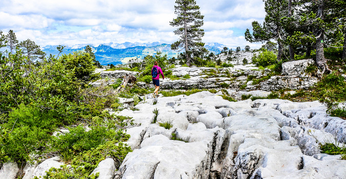
The Parmelan Plateau: Immersion in the heart of the lapiaz
D+ 380m
D- 380m
Duration: 4h30
Type of route: Loop
Difficulty: Occasional walker
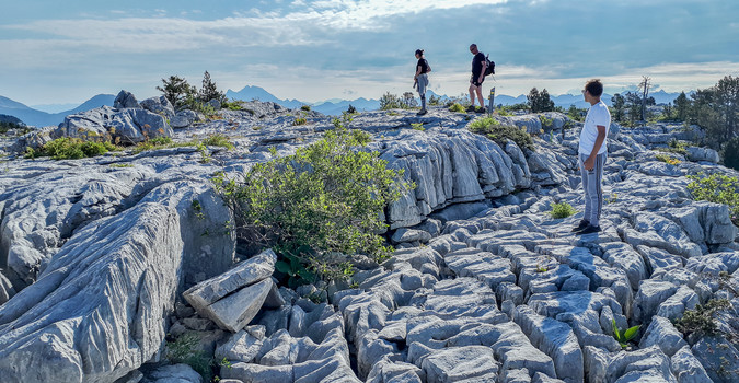
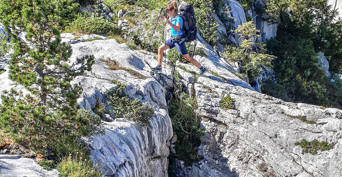
The Parmelan plateau is a geological curiosity of the area. At its surface, you will evolve in an essentially mineral atmosphere. The rock, fractured by the alpine orogeny, is slowly dissolved by the action of the water that infiltrates it. This creates the characteristic landscape of limestone environments: the lapiaz. The result is numerous cavities and chasms of varying depths. Moreover, it is a land used by speleologists to discover the bowels of the Earth.
Several routes can lead to the summit of Parmelan (Tête du Parmelan - 1832m).
The itinerary that we propose classically (loop of about 4 hours of walking) consists of parking at the chalet de l'Anglettaz.
Beware the access road is in very bad condition.
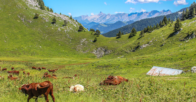
We leave in the direction of the large ice-house. The beginning of the hike will be in mountain pastures, where cows of the abundant Montbéliarde and Tarine breeds come to graze. The trail then merges into the forest of hook pines. These trees are wonders of adaptation to extreme conditions. They can grow on poor soils and withstand the extreme cold of winter. At the level of the big ice box, there is a path to go and contemplate this geological curiosity. You will be able to observe ice on the surface which is lost in the depths of the chasm. Be careful not to slip into the hole! After walking on the lapiaz, we join the main path that leads us to the source of the tour. This karstic resurgence sometimes serves as a source of water for the cow herds in the area.
Be careful, never consume water in the mountains without first filtering or sterilizing it.
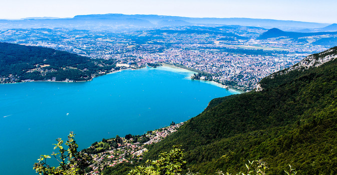
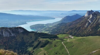
The itinerary continues and the landscape is gradually being discovered. In the foreground, we observe the Glières plateau and its large mountain pastures which give way to the Aravis mountain range and finally the Mont-Blanc in the background. At the bend in the path, we reach a first cavity where we can easily touch the snow and refresh ourselves in hot weather. The second cavity, deeper, is called the cave of hell. From there, the trail will go mainly on lapiaz to the Parmelan hut. A good exercise for psychomotricity because the terrain is riddled with holes and small cracks. Concentration is the key word if you don't want to spend a leg in a hole. The arrival at the Parmelan refuge is the highlight of the show. We are at the top of an escarpment of several tens of metres which gives way to a panoramic view of Lake Annecy, the Bauges Regional Nature Park to the west, La Tournette to the south, the Jura to the north and Lake Geneva.
The Parmelan refuge (guarded only in summer) is an ideal place to eat, drink a good beer and even sleep. You will be warmly welcomed by Philippe and his team.
After this contemplative break we will take the descent path towards the large montoir then the small montoir and finally the chalet de l'anglettaz.
There are other possible routes (more difficult) on the Parmelan plateau starting from the burnt wood, from La Blonnière or even from the car park of the Diau cave.
Be careful, it is not advisable to walk on the Parmelan plateau in stormy and foggy weather. The ground can become slippery and the markings difficult to spot. Also, always take enough water because, as you have understood, there is no water on the plateau.
Discover the geological curiosities of the Parmelan plateau with a mountain guide from the Annecy Guide Bureau Registration here
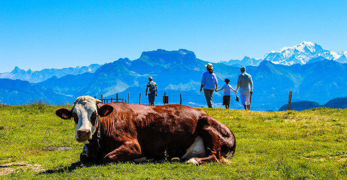
The Semnoz mountain pastures: Panorama 5* on the Northern Alps
D+ 150m
D- 150m
Duration: 2h30
Type of route: Loop
Difficulty: Beginner walker
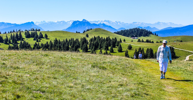
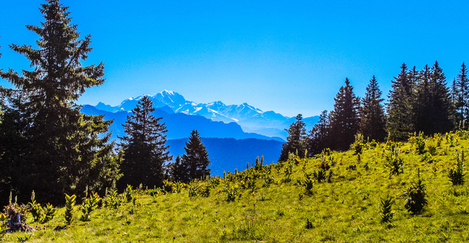
Semnoz is the mountain of the Ancients, so to speak. Only half an hour from the centre of Annecy, you find yourself in a mountain landscape with one of the most beautiful panoramas of the Northern Alps. In winter Le Semnoz is also a popular alpine and nordic ski resort for the inhabitants of Annecy. In summer, the snow gives way to grass and mountain flowers. The summit of the Semnoz is then transformed into magnificent mountain pastures. The relief is gentle and therefore allows a first approach to hiking for children and beginners.
We generally propose a loop itinerary, starting from the restaurant hotel "les rochers blancs". The first ascent leads us to the top of Semnoz: the crest of Châtillon which culminates at 1702m. The view is exceptional over a large part of the Alps and the Jura. On a clear day, we can observe the Massif des Bornes, the Aravis chain, the Mont Blanc massif, the Bauges massif, the Beaufortain massif, the Vanoise with the Grande-Casse and the Grande Motte, the aiguilles d'Arves, the Massif des Ecrins with the Meije, Belledonne and finally the Chartreuse massif.
The rest of the route continues partly on the GR de pays des Bauges in the direction of the chalet de Gruffy. We will meet many herds of cows, which will be an opportunity to talk about local pastoralism and the Tome des Bauges, a cheese with a protected designation of origin from the Bauges massif. Arriving at the Chalet de Gruffy, we will branch off towards the crêt de l'aigle, one of the exceptional viewpoints of the Semnoz.
We can see the largest natural lake in France: Lake Bourget, like Lake Annecy (the second largest natural lake in France) is also of glacial origin. A short break will be an opportunity to discuss the theme of glaciations and the impact of the erosion of these glaciers on the geomorphology of the Alpine valleys. After this break, we will set off again in the direction of the Leschaux chalets. This mountain pasture farm, which dates back to the end of the 18th century, is still in operation today. You will be able to buy cheese (Reblochon, Tome des Bauges, Abondance, etc.) at an unbeatable price.
The end of the route will be via the "courant d'ère" and the crêt de Châtillon.
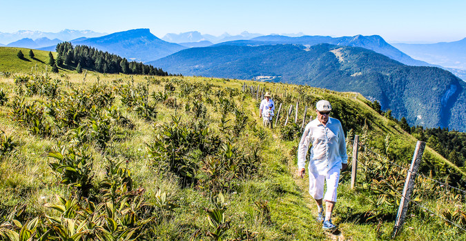
The tip of Talamarche: In the heart of the Massif des Bornes
D+ 710m
D- 710m
Duration: 5h30
Type of route: Round trip
Difficulty: Regular walker
The tip of Talamarche is a peak of the massif des Bornes which culminates at 1852m. It is a very beautiful hike starting from the chalet de l'aulp (departure for La Tournette) which can be done in preparation for the ascent of La Tournette.
Beware, the access road to the chalet de l'Aulp is a track gullied in places. Access by car can be tricky.
The departure from the Chalet de l'Aulp is initially downhill. We go through the forest and pass some gullies which can be filled with snow at the beginning of the season.
So be careful on your spring outings, these few passages are delicate and dangerous.
We leave the forest to return to the mountain pasture of the chalet des crottes. The view is clear over Lake Annecy, the bay of Talloires and the Roc de Chère. The route continues on the GR 96 towards the Col des Nantets. The mountain pasture of the Nantets chalets is often an opportunity to observe the local breed of sheep "Thônes et Marthod" with its white fleece and its characteristic black spots on its muzzle and eyes. From the Col des nantets, the climb up to Roc Lancrenaz is steeper and more aerial. We first wind our way through the forest before reaching a ridge where a herd of goats is often seen. The pas de l'Aulp is equipped with a cable for people prone to vertigo, the passage is relatively short. Once these difficulties are over, the path becomes much easier. We move on the mountain pasture laughing on it where the tarines and abundance graze the good mountain grass. We leave the chalets of the aulp laughing on our right to attack the last part of the climb up to the tip of Talamarche.
Be observant, there is often a solitary chamois lying in the shelter of a tree in the area. Once at the top, we will reach our picnic spot via a ridge path.
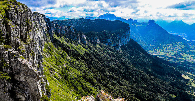
The view is breathtaking over Lake Annecy and the teeth of Lanfon below. In front of us stands the magnificent synclines of the Bauges Regional Nature Park. These folds linked to the deformation of the Urgonian limestone bars are a geological curiosity of the park, partly thanks to which the park was awarded the "Geopark" label in 2011.
The return journey will be via the ascent route.
Discover the Talamarche peak in safety with a mountain guide from the guide office
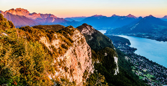
Mont Veyrier: The balcony of Lake Annecy
D+ 820m
D- 820m
Duration: 5h30
Type of route: Loop
Difficulty: Good walker
Mont Veyrier (1291m) takes its name from the village at its foot: Veyrier du lac. A very popular and among the most expensive in France. The Salomon family, Yoann Conte and the Mérieux foundation are among its inhabitants. The view of the lake, the privileged sunshine and the constant pressure of real estate are the main reasons for this.
The itinerary we propose is one of the few hiking trails in the area accessible from the shores of Lake Annecy. This sporty hike will allow you to reach a superb ridge path with numerous viewpoints over Lake Annecy and its mountains.
We start our hike from the small harbour in Annecy le Vieux. The first part of the climb will be in the forest. The path is winding up to the Pré Vernet, the slope is constant and sustained.
In order to limit soil erosion it is important to follow the main path and not to cut. Indeed, too many bad practices consist in going dredging in the slope and creating by dint of force paths in the slope. As soon as it rains, the runoff water uses its paths and gullies them deeply. The result is a transport of material downstream and a destabilization of the slope.
The arrival at the Pré Vernet allows you to take a short break, the slope softens. We continue our route on the GR de pays Tour du lac d'Annecy towards the Col des Sauts. The ascent is steeper. The arrival at the Col des Sauts at 1170m is our first reward. A superb view of the lake, the Mont-Veyrier escarpment, the Tournette and the Bauges is before our eyes. A small bench set up there will be perfect for a short break. The rest of the hike is the most interesting part of the hike because it takes the ridge path. The path winds above the large rocky bar that dominates Veyrier from the lake and passes through the highest point of Mont Veyrier at 1291m and then via Mont Baron at 1295m.
The evolution takes place on an alternation of vertiginous turns and passages in the forest, a real balcony over Lake Annecy.
Passing the Mont Baron, we reach a platform which is none other than the remains of the former arrival station of the Veyrier cable car from the lake, which was dismantled in 1988. The descent continues via a chained passage in the direction of the smugglers' pass. We go into the forest under Napoleon's hat. The end of the route will take place on magnificent small paths, in the direction of Talabar above the famous biclop climbing spot.
Don't hesitate to call the Annecy guide office if you want to discover the most beautiful trails around Lake Annecy. You will be guided by a mountain guide who knows the area perfectly and will be able to guide you safely on the most beautiful itineraries of the area.
Click here to discover our offers and do not hesitate to contact us by phone for more details