The Aravis massif is located in the northern pre-Alps and extends over about 25 km. Classified as a "Natura 2000 site" since 2006, this limestone mountain range is mainly composed of plateaus, coombs, cliffs, alpine pastures and summits, some of which exceed 2000 meters in altitude. Its highest point is the Pointe Percée, at 2750 meters of altitude.
Other summits are also known, such as: the Mont Charvet (2538 m), the Mont Fleuri (2511 m), Tardevant (2501 m), the Tête de Paccaly (2467 m), Roche Perfia (2499 m), Tête Pelouse (2537 m) and the Mont Charvin (2407 m)
The Aravis pass is at an altitude of 1486 meters and marks the separation between the departments of Savoie and Haute-Savoie. From here, you can enjoy a panoramic view of the Mont-Blanc! The pass is accessible by car all year long except in case of heavy snowfall. At the top, there are many restaurants, shops and even a small chapel.
The Aravis massif gathers several ski resorts, the most famous of which are La Clusaz, Le Grand-Bornand, Manigod or Saint-Jean de Sixt. These resorts are both family and sporty, with a typical motagnard charm, and have kept their soul of mountain village and hamlet, with a traditional architecture (mainly made of wood, slate and stones).
Thônes is considered as THE capital of the reblochon cheese and also the Gateway to the Aravis because the small town is located halfway between Annecy and the ski resorts.
Hiking, climbing, via ferrata, ski touring, off-piste skiing, mountain biking, paragliding, mountaineering... The Aravis are an ideal playground in any season, for all outdoor activities lovers and nature lovers! As you can see, the Aravis massif is an excellent place to practice sports activities in a preserved environment.
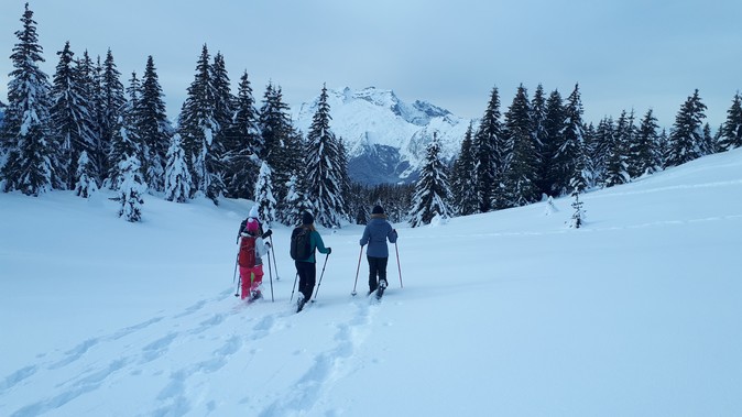
In this blog article dedicated to the Aravis, we would like to share with you all our good tips for varied snowshoeing excursions accessible to all levels!
Preparation, safety and equipment
Snowshoeing is for all those who want to enjoy the snow without skiing and for all those who love wide open spaces far from the ski lifts. This activity is for everyone, from beginners to advanced.
From the Aravis pass, take the path that goes to Planchaux via the Aravis spring. (Be careful with the slopes upstream of the Aravis spring which can be avalanchey! Study the risk of avalanche before venturing in this sector). Then you go up on the ridge at the level of the iron cross from where there is a superb view on the Mont-Blanc massif. The descent is done via the zorette.
2 - The Danay ridges (Dist: 4,3km / D+: 230m / D-: 230m / About 2h walk)
From the chapel of Confins you will go up on the track which takes the direction of the head of Danay. The beginning of the itinerary is steep but it becomes gentler afterwards. The view opens up on the Aravis chain. You will pass a first farm and then, when you arrive at the second farm, you will be able to take a path that goes down in the direction of the frasses in order to complete the loop.
Itineraries for the more athletic
3 - Paccaly and la bombardellaz (Dist: 6,8km / D+: 205m / D-: 2050m / 2h to 2h30 of walking)
Starting from the Confins sector, we propose a round trip to the foot of the wild Aravis combes and up to the Bombardellaz refuge. This round trip itinerary is to be used if the risk of avalanche is limited because you are downstream of the combes.
4 - Loop on the head of Danay (Dist: 11km / D+: 610m / D-: 610m / 4h30 to 6h walk)
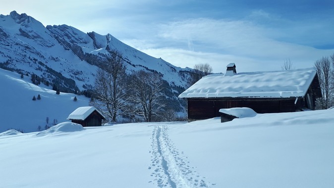
From Les Confins, we invite you to make a loop (for the day) around the Danay head, a superb viewpoint on the Aravis chain. You will start your journey by following the mountain southwards to reach the col des mouilles. Then you go up towards the Danay mountain pasture from below before passing the Danay farm where you can stop to eat a good Savoyard dish in the warmth. A steep ascent will lead you to the head of Danay which culminates at 1731 m before joining the ridges and finally going down to the Confins.
Discover also our snowshoe outings on the side of La Clusaz - Manigod with a mountain guide from the Annecy guide office:
1 - The Samance plateau (Dist: 4,5km / D+: 320m / D-: 320m / 2h30 to 3h walk)
Starting from the heights of Chinaillon, we propose a nice loop on the Samance plateau. The beginning of the ascent is on a track, we reach the old hamlet of la Gaudinière made up of magnificent old chalets. You can then go back up to the Buclon (be careful not to venture too close to the slopes as they are exposed to avalanches). In general you will be able to observe ibexes looking for food on this side of the slope where the snow melts more quickly. Then go back down to the starting point via the chalet des crêts.
2 - Loop of the Vieux Chinaillon (Dist: 8,5km / D+: 300m / D-: 300m / 3h to 4h walking)
Starting from the Vieux-Chinaillon, we propose you a nice loop between alpine pastures and spruce forests. The beginning of the walk is on a groomed track. You pass the picturesque hamlet of La Bouvardière, then go up in the direction of La Culaz. You are now under the rock of Charmieux and you can see a big part of the Aravis chain. Then head southwest towards the Parchets and the Tannaz which are pretty mountain pastures lost in the middle of the forest. You can then return under your steps by joining the place called "Les mouilles" and find the way back.
Itineraries for the more athletic
3 - The Aravis balcony (Dist: 10km / D+: 570m / D-: 570m / 4h to 5h walking)
As its name indicates, this is a route with a magnificent view of the Aravis. The hike starts in the Bouchet valley, at the level of the chapel of the place called Bouchet. It is an out-and-back walk to reach the alpine chalet of the Grand-Montagne located at 1597m of altitude just below the Mont Lachat of Châtillon. From the chapel, take the direction of the barns of bouchet, the chalets of Saytels and the parking of the cross (1351m). Then head east via the mountainside path to reach the chalet de la Grand-Montagne. The return is done by the path of ascent.
4 - The Roc des tours (Dist: 8,2km / D+: 625m / D-: 625m / 5h to 6h walking)
Climb the Roc des Tours (1994m) which dominates the Chinaillon resort. This round trip itinerary is to be considered when the avalanche risk is low because the ascent trail is exposed to the steep slopes of the aiguille verte and the Buclon. On the other hand, a part of the route evolves on a karstic ground. It is therefore preferable to wait for a sufficient snow cover so that the cracks and holes are completely filled by the snow. The beginning of the hike is from the heights of Samance. You will take the summer trail in the direction of the lake of Lessy. Arrived at the point of altitude 1568m continue your ascent without approaching the steep slopes under the aiguille verte. Arrived at the pass at 1881m, will begin the evolution on the lapiaz before joining the summit. You will then benefit from a superb panorama on the valley of entremont, the valley of Mayse and the surrounding summits of Bornes and Aravis. The return is done by the way of ascent.
Discover also our snowshoe outings in Grand-Bornand with a mountain guide from the Annecy guide office:
1 - Tour of the head of Cabeau (Dist: 7km / D+: 150m / D-: 150m / 2h to 2h30 of walking)
We propose you an easy loop in balcony from the pass of the Croix Fry. From the pass, go down in the direction of Manigod to join a path which leaves towards the South at the coast 1420m. You pass the chalet of Andran then the chalet of Vé la Marie in Noré. Be careful not to linger on the path between these two chalets. The progression can be delicate and potentially dangerous because of the ice and the snow flows coming from the steep slopes upstream of the course. Continue the route on a wide path where the view opens up on the Sulens and the southern part of the Aravis. You pass the farm of la Frasse at 1440m and join the station of l'Étale at the pass of merdassier. You complete the tour via a groomed path on the eastern side of the tête de Cabeau.
2 - On the ridges of Beauregard (Dist: 5,3km / D+: 260m / D-: 260m / About 3h walking)
Les frêtes de Beauregard is a nice snowshoe walk to do in a loop from the Croix Fry pass. A part of it is off the trail, you need to have a good sense of direction. From the pass, go up the road behind the building "la ruche" in the direction of the plateau of Beauregard. You can follow the summer path which is marked out. You will then have to take the ridge path which leaves on the left. Once you have crossed the ridge with its magnificent views, you will come back on your steps via the plateau of Follières which faces the Aravis pass and the Mont-Blanc. You will have to turn east to come back above the Maison des Bois, Marc Veyrat's restaurant.
Itineraries for the more athletic
3 - The mountain of Sulens (Dist: 8,5km / D+: 540m / D-: 540m / About 4h walking)
The mountain of Sulens (1828m) is a classic itinerary for the initiation to ski touring because it offers relatively gentle slopes. However, you have to be careful about the risk of avalanche on the western side of the mountain. The itinerary starts at the col de Plan Bois at 1300m of altitude. You take the track until you reach a chalet at 1469m. Continue on the marked summer path until you reach the alpine farms which are in the valley under the Greffaz. Do not approach the steep slopes of the Sulens as this is an accumulation area and potentially avalanche-prone. Once you arrive at the pass at 1740m you can reach the summit of the Sulens by the ridge. Be careful with the possible cornices that could have formed with the wind. The return is done by the path of ascent.
4 - La pointe d'Orsière (Dist: 11,5km / D+: 570m / D-: 570m / 4h to 5h walking)
We propose a round trip itinerary far from the busy areas of the Aravis ski resorts. Our route starts on the north side of the Sulens mountain at the level of the Torchon at 1180m of altitude. The itinerary starts on a track on the side of the mountain. You pass the Combe then at the altitude of 1276m you take on the right in the direction of Arbarête. You continue your way in the direction of Macheux and finally to the point of Orsière which culminates at 1750m. You will then face the Étale and the Mont-Charvin. You can come back by the same way or continue to the Riondaz and take the "Plan des mouilles" before going back to the Arbarête to make a loop.
Discover also our snowshoe outings on the side of La Clusaz - Manigod with a mountain guide from the Annecy guide office:
At the Annecy Guide Bureau, snowshoeing outings are supervised by state-qualified mountain guides who are mountain professionals.
They know the mountain perfectly and will guide you safely on unmarked itineraries, most often off the beaten track. On each outing you will be provided with quality equipment (snowshoes, sticks, headlamps depending on the outing). Depending on the chosen formula (private or group) you will spend a great moment of conviviality on the most beautiful snowshoe sectors of the Aravis. The snowshoeing trip will be an opportunity to learn many things about the mountains that surround you, about the fauna that survives the winter in this hostile environment. You will be relentless in identifying the tracks left in the snow.
Equipment rental
You will find many equipment rental companies throughout the Aravis ski resorts. For those who come from Annecy for the day, we invite you to stop at Versant Nord which is located in Thônes because the store is on the side of the road and therefore very easy to access.
How to get there
By car:
From Annecy center, it takes about 50 minutes of driving when traffic conditions are fluid.
Important : During winter, special equipment is mandatory, chains or snow tires at least to access the resorts. More info on road conditions.
By bus:
All year round, it is also possible to take the bus, from the bus station of Annecy to reach the bus stations of Thônes (about 40min), La Clusaz (about 1h), le Grand-Bornand (about 1h10). In order to reach the snowshoeing spots, you will have to take the local Skibus des Aravis shuttles.